

This post is one in a series of posts from our recent trip to the Canadian Rockies and Glacier National Park in Montana. Check our our previous post about Moraine Lake and Lake Louise. More to come soon!
Our trip to Lake O’Hara started on April 23, 2019 – more than two months before we arrived in Canada. At 8AM Moutain Time, we started clicking across three computers and four web browsers to grab one of the 1,000 seats on the bus to this secluded part of Yoho National Park, across the border in British Columbia from Lake Louise. Parks Canada enforces a strict quota on visitors to keep this area pristine: when we finally arrived in early July, we found challenging trails, impossibly blue lakes, jagged peaks, and plenty of solitude. After we visited Lake O’Hara, we also took the opportunity to check out nearby Takakkaw Falls, one of the tallest waterfalls in Canada.


Itinerary
- February – Enter the lottery to snag a ticket on the bus to Lake O’Hara. We’d recommend reserving the 8:30AM bus if it’s available.
- 8:00AM – Arrive at the Lake O’Hara parking lot and check in for the 8:30AM bus departure [1 hour drive from Banff].
- 9:00AM – Hike the trails at Lake O’Hara. Consider the Opabin Loop [4.1 miles, 1125 ft elevation change] in the early season, or extend your trip to Lake Oesa and some of the alpine routes once the snow is clear [5+ miles].
- 1:30PM – Come back to the Le Relais day shelter and enjoy a seat by the wood stove and a warm cup of tea while you wait for your return bus.
- 2:30PM – Take the bus back to the Lake O’Hara parking lot.
- 3:00PM – Drive to Yoho Valley and take a short walk to Takakkaw Falls. [30 minute drive, 1 mile walk]
- 4:00PM – For dinner, consider heading over to one of the restaurants in Field, BC or at Emerald Lake, or else head back to Banff and call it a night.
Details
Just before 8:30AM, we boarded our yellow school bus for the trip to Lake O’Hara. The bus trip takes about a half hour; it was a bumpy but scenic ride, with a mix of forest and mountain views. The bus dropped us off at the Le Relais shelter near the lake.
Even on a cloudy morning, our first view from the shoreline was incredible! From here and all along the shore, we had peek-a-boo views through the trees of the “seven veils” or “seven sisters” falls, which are pretty unique because the water doesn’t come tumbling down over the rocks, but rather percolates through the boulders and comes shooting out from the cracks.

- Our first view of the Lake O’Hara shoreline with the seven veils falls in the far center
There are lots of great hiking options at Lake O’Hara. We planned to do a loop around the lakes on part of the alpine route to get some high perspectives on this beautiful valley. In retrospect, in early July, we’d recommend doing the 4.1 mile Opabin Loop to start because even a little snow on the higher alpine trails can get tricky (read on to find out more).

We walked clockwise around the lake, past some rushing streams and gorgeous mountain scenery. After 0.6 mi, we took the trail towards Lake Oesa, which climbs parallel to a stream, some tarns (small lakes), and a cascade that connect Lake Oesa and Lake O’Hara. The step-like nature of this path is a result of the step-like erosion of the glaciers that formed this area. The most dramatic vista on this trail is Lake Victoria which sits about 1.4 miles up the trail.

The water inside the lake is very still, but the water gushes quickly along streams from both the inlet and the outlet of the lake. The rushing water and steep terrain made for a very interesting next segment of the hike.

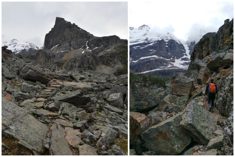
From Lake Victoria, there are a couple of options for continuing on. You can either head towards Lake Oesa and then connect to the rest of the trails, or else connect directly to the Yukness Ledges Alpine Route, which eventually leads towards the Opabin Plateau Area. We decided to take the alpine route directly, making a small detour to get a glimpse of Lake Oesa along the way. Oesa is a first nations word for “ice,” and indeed the lake was mostly frozen over when we saw it.

The area around Lake Oesa and the Yukness Ledges Route were some of the most interesting but hardest segments of any hike we’ve done. The route any time of year would involve scrambling over rocks, but in the early season, we had to walk across a stream where the stepping stones were all underwater and walk up several snow slopes, including one fairly steep one. Spikes would definitely help, but the bigger problem in early July was post-holing, i.e. falling through the snow into the rocks. We found it helpful to test out the snow by tapping with our boots and moving quickly to avoid sinking in the snow.

Notwithstanding the early-season challenges, the trails at Lake O’Hara are really amazing to exprerience. They were laid down by a dedicated group of mountaineers in the early to mid 1900s, including Mary Schäffer Warren, Lawrence Grassi, and George K.K. Link & A. Carson Simpson (the founders of the Lake O’Hara Trails Club). Because of their foresight, continued stewardship, and the quota system imposed by Parks Canada, the trails in the alpine region are very unique: narrow and so disguised in the rocky landscapes that it can be hard to see them sometimes! On the alpine trails, we clued in that we could see which way to walk by looking for rock cairns along the sides of the path and looking for small painted double-yellow line in blue squares, which served as trail markers.
After about 3 miles, we descended from the Yukness Ledges to Hungabee Lake, which at about the midpoint of the Opabin Plateau. Many trails criss-cross through this region, all the way from Opabin Lake down to Lake O’Hara. We wandered through the landscapes around the Moor Lakes for about 0.75 miles, painted with almost every colour of the rainbow, especially as the sun peaked through the clouds.

Our destination in this area was the Opabin Prospect, a cliff-top overlook where we had a panorama over Mary Lake, Lake O’Hara, the nearby cliffs, and the cloudy summit of Cathedral Mountain in the distance. There are actually two viewpoints at the Opabin Prospect: the one in the trees that is well-signed from the trail, and the rocky outcrop shown below. If you head out on the rocks, be careful as there are some pretty steep crevases in between the big boulders!

From the prospect, we descended back down the Opabin West Trail to Lake O’Hara, hitting the shoreline trail after about another mile (5 miles total). The trail down gave some awesome views of Mary Lake from a different perspective, as well as backwards views over to Mount Biddle in the distance.


We got back to the Le Relais shelter after just under 5.5. miles of walking with perfect timing – it started pouring right when we got back! The carrot cake at the shelter was okay, but being able to sit inside and warm up with the wood stove while waiting for the bus was the real treat here! Note that the shelter only takes Canadian cash (no cards or other currency).
We took the 2:30PM bus back to the Lake O’Hara parking lot, and after the rainstorm the sky actually cleared up quite nicely. We decided to drive about a half hour to Yoho Valley, home to Takakkaw Falls, the second tallest waterfall in Canada (total height). We could see (and hear!) falls from the parking lot itself, but a 0.5 mile paved walk took us right up to the base of the falls. There were a decent number of people here, but you could get unobstructed views of the falls and river snaking towards Wapta Mountain from several stopping points along the trail before the base.


This was a pretty spectacular conclusion to our excursion: we were considering continuing on to Emerald Lake and some other stops in Yoho National Park to canoe and have dinner, but we we had a long day of driving ahead and wanted to get back to our hotel. On the way out of the park, we got some amazing views of the railroad tunnels that played an important role in connecting Canada from coast to coast.

Logistics
- Be sure to arrive about 30-45 minutes before your bus departs in either direction. When you board the bus for the first time, you’ll be handed tokens to ride the bus out: make sure you don’t lose these!
- Though you’re more likely to see pikas and marmots, Lake O’Hara is in grizzly country. Make sure you carry bear spray and know how to use it. Tell the volunteers at the Le Relais shelter if you see any large mammals or bear scat.
- You need a valid park pass to be displayed in your vehicle to park at Lake O’Hara. Make sure you get this before your trip.
- Prepare for being in the backcountry. Hiking on the alpine routes at Lake O’Hara is like hiking in the backcountry. In addition to the “ten essentials,” we found that raingear, good mid to high waterproof boots, snow spikes, and hiking poles would be quite useful, especially in the early season.
- There are pit toilets at the parking lot and near the Le Relais shelter, where the bus drops you off. These are possibly the best smelling outhouses we’ve ever seen – probably because of the low traffic coming through the area :).
How to Get to Lake O’Hara – Bus Tickets
Parks Canada has a very strict quota system in place for Lake O’Hara to protect the fragile ecosystem of this high alpine environment, where the vegetation can take 60 years to grow but can be wiped out with just a few footsteps. The parking lot for Lake O’Hara is 11km from the lake, so you must travel by Parks Canada bus, shuttle, or on foot to reach the lake.
Staying or Camping at the Lake
The first set of spots on the buses to the lake are reserved for people who are spending the night. To stay at the lake, you need to reserve many months in advance of your trip (as early as the previous fall up to sometime in January). To find out more about staying at the lake, visit the Lake O’Hara Lodge, the Alpine Club of Canada, and the Parks Canada Camping Reservations pages.
Day Use – Bus Tickets
The rest of the spots are for day use visitors who want to travel to Lake O’Hara on the Parks Canada bus. There are only 1,000 spots available for day use visitors on the bus for the entire summer season. 17,000 people compete for these spots, so your chances of getting one are very slim. Historically, Lake O’Hara day use reservations opened in April. Starting in 2020, you now need to apply by lottery in February. See https://www.pc.gc.ca/en/pn-np/bc/yoho/activ/randonnee-hike/ohara/reserve for more details.
Cancellations and no shows
First, you can check back on the website to see if there are any cancellations. These are rare but possible.
In general, there aren’t that many no-shows on the day of the bus trip, but you can consider waiting at the Lake O’Hara parking lot to see if any spots become available. You need to get there very early to do this: we saw about 8 people waiting for openings the morning we were there, far more than the expected number of no-shows. Note that the quota at Lake O’Hara is for visitors, not bus seats, so you may not get to go to the lake even if it looks like there are spaces on the bus.
Commercial Guide
You can also consider going with a commercial mountain guide, but these groups must compete with the campers on the Parks Canada phone line to get a spot on the bus. From what we saw on various websites, tours are not guaranteed and you need to pay most touring companies (a lot of money) before you even head out to the lake. This option did not seem very good to us, but we’d love to hear if you had a positive experience with a mountain guide.
Walking In
Finally, you can walk to Lake O’Hara along the 7 mile access road. The road has a 2100 foot elevation gain. It has some mountain views, but it is mostly in the forest. If you do walk in, you have to make sure that you are prepared to walk out, as seating on the return buses is not guaranteed. We met one couple who walked in during our visit – they were pretty beat by the time they made it to the lake shore, so they didn’t wind up climbing to any of the higher trails (which really allows you to experience the beauty of the area). Also, they almost didn’t get a seat on the bus back out to the parking lot. If you do walk in, make sure to bring (Canadian!) cash for the bus trip out.
If you don’t think you’ll enjoy walking to Lake O’Hara, consider some of the other spectacular destinations in Yoho (like the Iceline Trail and Emerald Lake), where there is gorgeous mountain scenery but fewer crowds than in the Lake Louise area.
Stay tuned for the next part of our adventure at Lake O’Hara, one of the most exclusive and beautiful destinations in the Canadian Rockies.

Wow, I don’t think I have ever seen anything more beautiful than Canadian lakes, your photos are absolutely amazing and so is Canadian landscape. Thanks for sharing and inspiring
LikeLiked by 1 person
Thank you for the kind words! The quartzite rocks, turquoise lakes, and grey mountains really painted these scenes with amazing colours!
LikeLiked by 1 person
So very beautiful! Great and thorough information too! Thanks for sharing!
LikeLiked by 1 person
Thank you! We put so much effort into planning our trips that we thought it would be a shame to not share this information with others to make their trips just as memorable.
LikeLiked by 1 person
I agree! It takes a lot not just to plan the trip but to prepare a post as well!!
LikeLiked by 1 person
This has got to be one of the most spectacular places in Canada—it’s my favourite park. Your photos are stunning.
LikeLike