

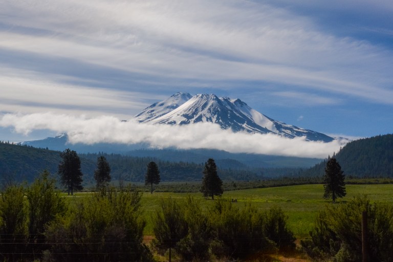
On Memorial Day weekend this year, we visited Mount Shasta, a captivating mountain at the southern end of the Cascade Mountain Range in Northern California. It takes about four to five hours to drive up to Shasta from the Bay Area, but once we arrived, there was so much to see and do within a one hour radius: challenging hikes, spectacular waterfalls, beautiful lakes, compelling art installations, and engineering marvels. And although some places we visited were crowded on this holiday weekend, we had to wait longer for our food at local restaurants than we did at any park entrance station or trail parking lot :).
Long Weekend Itinerary
Saturday (5.5 hours of driving, 2 hours of light walking, and 3 hours of hiking)
- Hit the road relatively early and drive to the Shasta Dam Visitor Center (~4.5 hours), planning to arrive before noon to get *free* tickets for the Dam Tour (~2 hours, including a 1 hour wait). Note: if you’d rather get right on the trail or want to leave a little later, you could visit the Dam on Monday morning on your way back to the Bay Area).
- Drive up to Castle Crags State Park (1 hour drive) and take the steep hike up to Castle Dome (~6.5 miles, 3 hours) for a tremendous view of granite spires and domes, as well as Mount Shasta.
- Drive to Dunsmuir or Mount Shasta town (10-20 minute drive) to have dinner and spend the night.
Sunday (~3.5 hours of driving, short walks, and 1 hour of hiking)
- Take a short morning walk up Yellow Butte (30 minute drive) to get a great view of Mount Shasta and the surrounding region.
- Just down the road (5 minute drive), check out the Living Memorial Sculpture Garden, a moving tribute to veterans, their families, and others affected by conflict.
- After grabbing some food, visit spectacular waterfalls along highway 89: McCloud River Falls and Burney Falls.
- Drive up to Castle Lake and take a short but steep hike up to Heart Lake (2.2 miles round-trip, ~ 1 hour), where you get incredible panoramic views of the area.
- Again, grab some food in Dunsmuir or Mount Shasta and call it a night.
Monday (~5.5 hours of driving, short walks)
- Start heading South, and on your way out take a brief walk to Hedge Creek Falls in Dunsmuir (10 minute drive).
- Drive down to Redding and sit down for a delicious breakfast served with care at Trendy’s (~ 1 hour drive).
- Check your watch as you cross the Sundial Bridge across the Sacramento River, (a few minutes to cross the bridge, more if you want to explore Turtle Bay Park or the arboretum).
- Head back to the Bay Area (~ 4 hours of driving)
Packing List and Resources
The hikes on this trip can be over uneven surfaces and across streams, so waterproof hiking boots are definitely in order. Because of brush and bugs, long pants would also be a good idea, and packing layers can help if it gets cold or windy on the trails at higher elevations. Make sure to bring sunscreen, snacks, and plenty of water! Because of the busy weekend, we found that some park bathrooms were out of toilet paper, so we were glad we always pack some of our own :).
There were two super helpful resources we used to plan our trip:
- Day Hiking: Mount Shasta, Lassen & Trinity Alps Regions, a book we were able to borrow from our local library that offers detailed descriptions of hikes in the area by region.
- Hike Mt. Shasta, a great blog that shows great photos from the trails to give you an idea of what to expect and lots of details about the geography of the area.
Saturday – The Cascade Wonderland
There was hardly any traffic as we left the Bay Area at 7:30AM, making our way towards I-5 via I-80 and I-405. Our first stop on this trip was Shasta Dam, about 20 minutes outside of Redding in the town of Shasta Lake. You can always walk across the top of the Dam, but to see the lower level and inside the power plant, you need to take a free tour. Space on the tour is limited to 40 people, and tickets are released at the Shasta Dam visitor center an hour before the tour begins.
We checked the website for tour times and decided to take the 1PM tour, so we arrived at the Dam around 11:50AM (after stopping in Redding to pick up a couple of sandwiches for lunch). We were the first people in line to get tickets! At the visitor center, we were informed that we weren’t allowed to bring bags and several types of electronics on the tour (cell phones and small cameras were okay), so we packed away these items in our car.
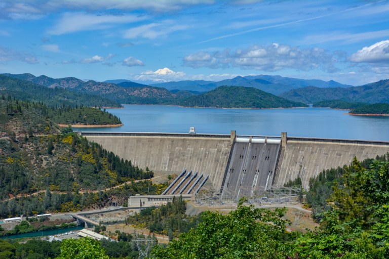
While we were waiting for our tour to begin, we ate our packed lunch and checked out the exhibits in the visitor center. Shasta Dam was built around the time of the Second World War as a way to control the flow of water into the productive agricultural region of the Central Valley and to prevent frequent flooding of some of the cities in the region. The Dam creates California’s largest reservoir, Shasta Lake.
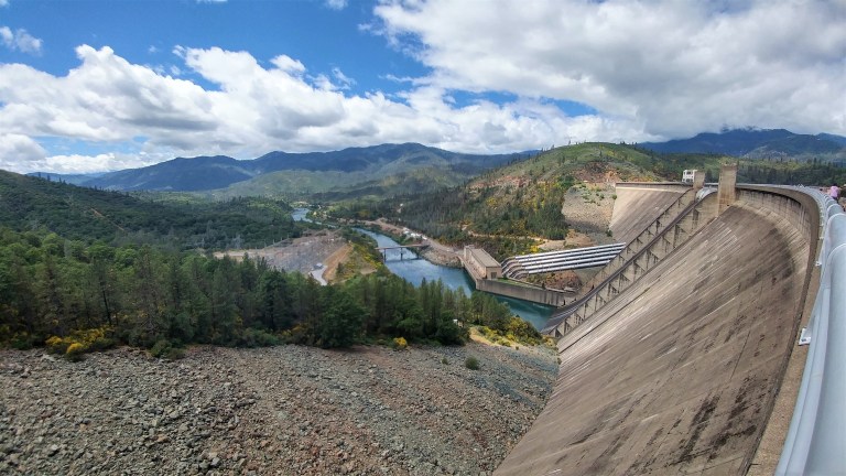
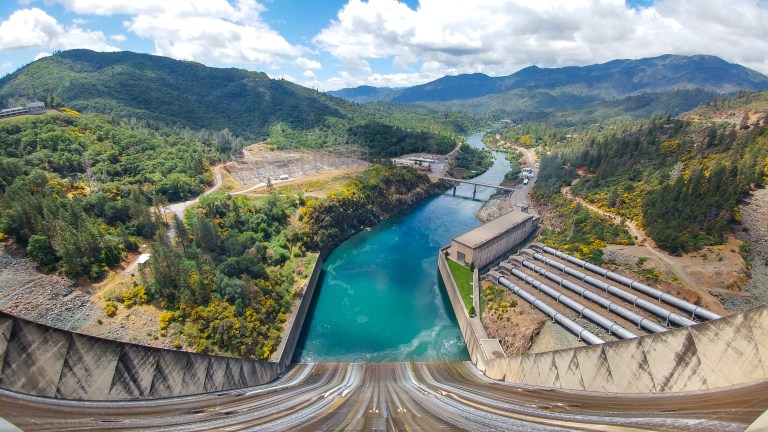
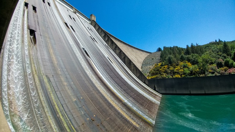
To get to the start of our tour, we walked along the top the dam, where we had particularly dramatic views of the river below the Dam.
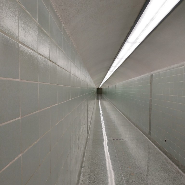
When our tour started at 1PM, we had to empty our pockets and clear a particularly sensitive metal detector, so we were happy that we weren’t carrying a lot of gear. After everyone in our group had cleared the detector, we were whisked down 13 stories deep into the dam itself. We got a sense of how thick the dam was (~543 feet at its thickest) when we walked through a hallway from one side of the dam to the other. The hallway creates a cool echo effect which everyone on our tour got a kick out of.
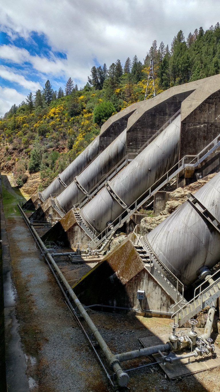
Next, we headed into the power plant. The water is carried into the plant by a series of pipes, where it causes hydroelectric generators to spin, producing enough electricity for 330,000 homes. Despite the incredible amount of electricity being produced, the plant was actually relatively quiet!
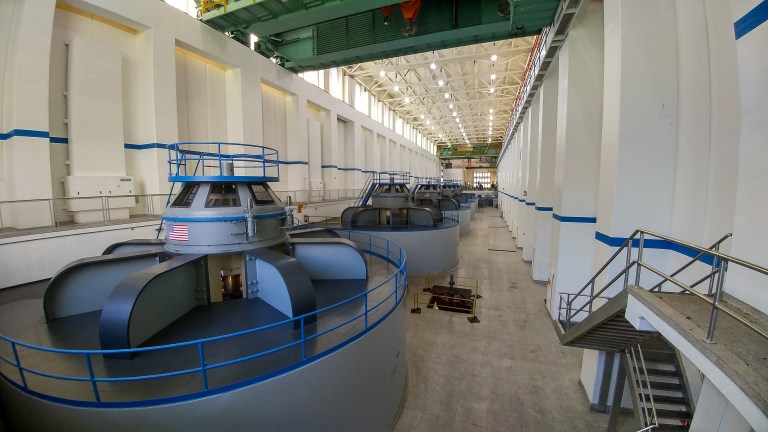
Back outside, we heard more about how the dam was constructed from concrete blocks, how the river was diverted through a railroad tunnel during the construction of the dam, and how the dam started producing power even before it was finished being constructed to assist with the war effort. All in all, our tour was pretty informative, and our guide tried to keep the mood light with his dam jokes :).
We left the parking lot around 2:30PM and drove back to the highway along Route 151, stopping at the large pullout at the side of the road to take in the view of the “Three Shastas” at the Shasta Dam Overlook: Shasta Dam, Shasta Lake behind it, and Mount Shasta in the distance.
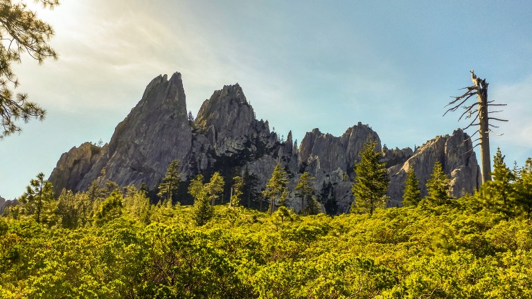
Our next stop on our drive north on I-5 was Castle Crags State Park. The Crags are sharp granite rock formations that jut out from a beautiful pine forest. They are visible from I-5, but they are even more impressive when you get up close. Some of the best views and hikes start at the Vista Point Parking Lot, a small lot at the end of a winding, single-lane road past the entrance station to the park (the entry fee was $8). When we arrived in the park, the lot was full, but by the time we had used the bathroom and put on sunscreen near the entrance station, the ranger let us know that a few spots had become available, so we drove on up. We were lucky, because the alternative was to access our hikes along Bob’s Hat Trail, which would have added a couple of hours and lots of elevation gain to our excursion!
We were contemplating two hikes in the park. For either of these hikes, you walk back down the road from the Vista Point lot to access the trail head. One option, Root Creek Falls, leads to a dramatic, multi-tiered fall backed by a large granite dome, but the rangers told water flow was very low during this Memorial Day Weekend. We therefore decided to hike the ~6.5 mile trail to Castle Dome, a huge granite dome with fabulous views of Mount Shasta.
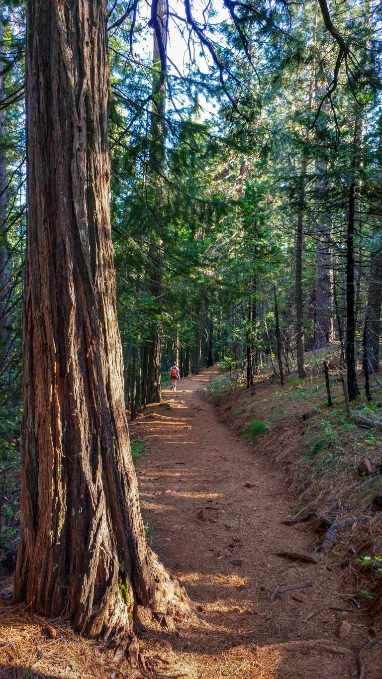
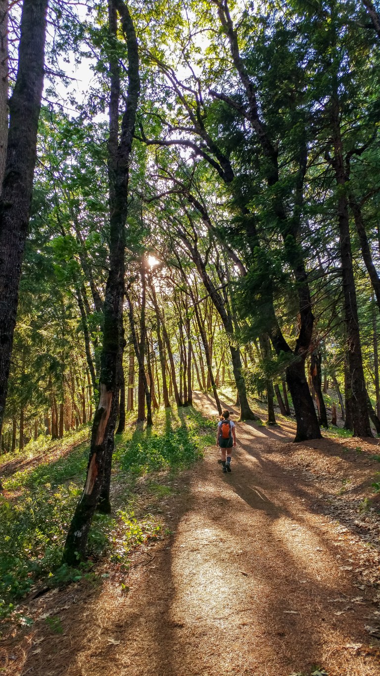
The trail to Castle Dome is a pretty unrelenting uphill hike. Even though it was only in the high 70s when we started, the trail felt very hot at sticky at lower elevations, but after about a mile, it was actually a little chilly because of the cool breeze blowing through the beautiful pine forest.
After winding through the forest for about 1.6 miles, we came to the junction with the Indian Springs Trail. The trail was worth the small diversion to see some of the crags up close as well a small trickle of water flowing out of the rocks through some lush moss and ferns.


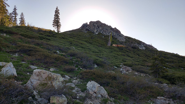
Back on the main trail, we soon came to the boundary of the park with Castle Crags Wilderness, where we got the first of many stunning views of Castle Dome and Mount Shasta side by side. Our favorite one was a bit further up the trail, just past the point when the trail goes through a split rock.
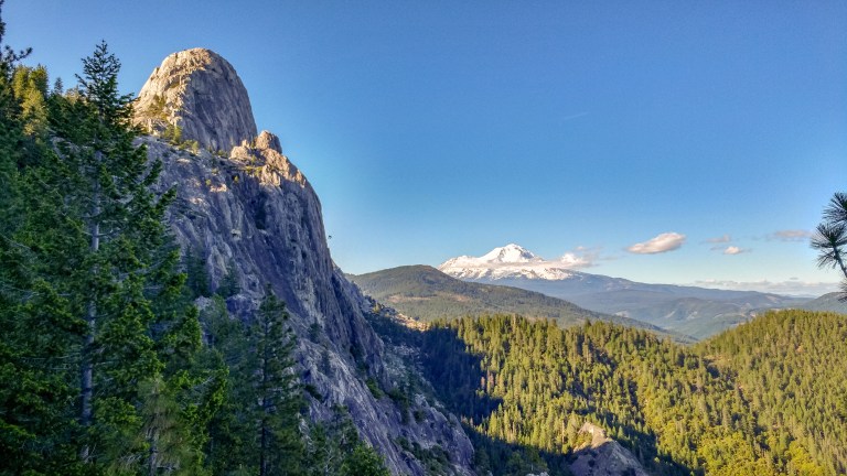
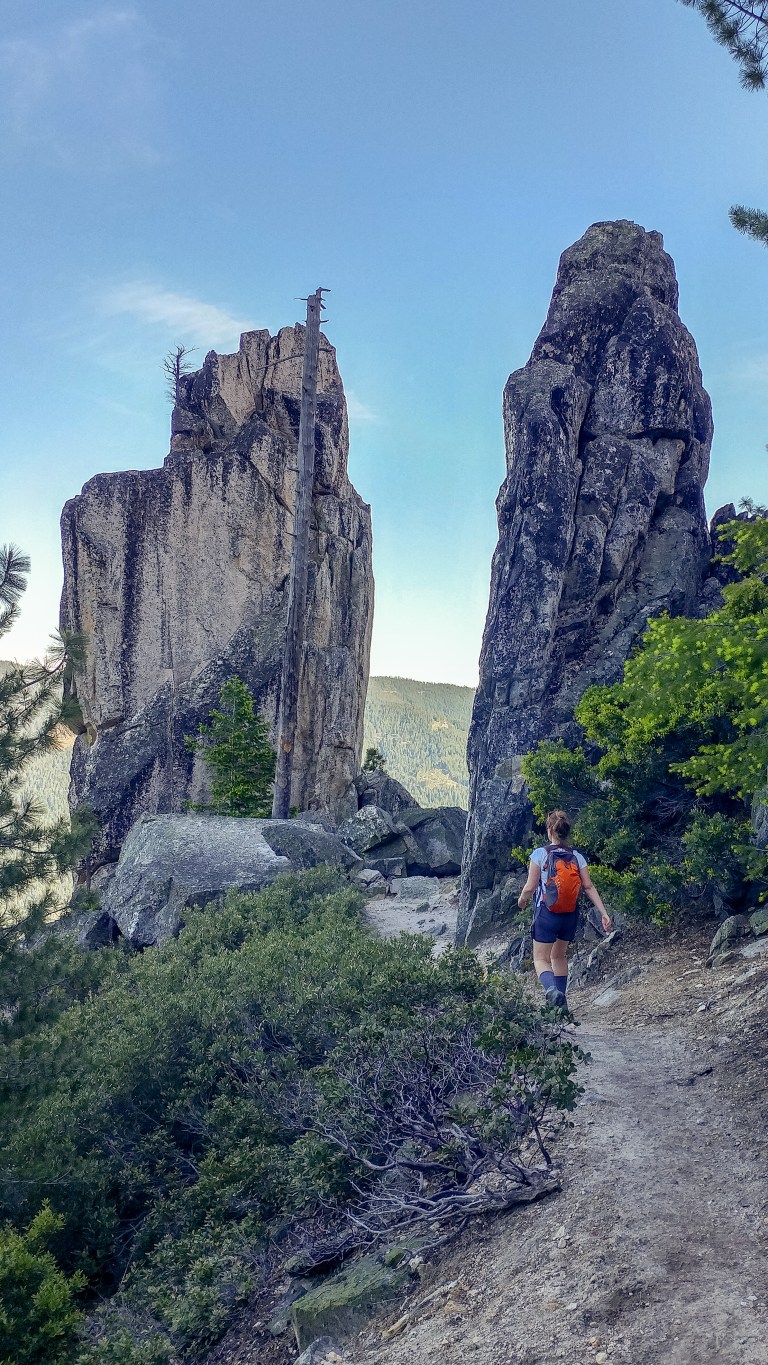
At this point, the trail became a bit more rocky and started winding between granite columns.
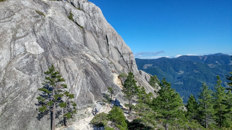
Finally, we made it to the base of Castle Dome. From the base, we had a great perspective on the dome’s enormity, as well as a view of more adventurous folks who had decided to venture further up the dome.
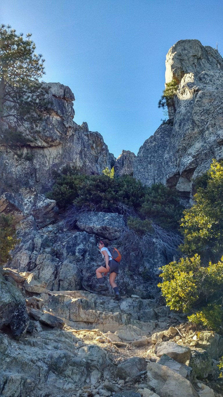
Up until this point, the trail was pretty clear, but in the rockier area near the top of the dome, we weren’t sure which way to go. After some trial-and-error, we found that the key was not to hike towards the dome directly, but instead to keep the dome on your right as you make your way uphill. A good landmark is an old dead tree with a second tree fallen beside it. If you follow the trunk (i.e. stay to the left of it), you wind up back on the main trail, directly facing the Castle Crags.


This part of the trail is also a great place to get a view of the crags.
After a couple of switchbacks, we found ourselves at a viewing platform which frames Mount Shasta beautifully between the sharp rock faces around Castle Dome.

From this point, we retraced our steps back to the parking lot and then through it to get to the Vista Point Trail. The trail is a lovely half-mile walk under deciduous trees. It was really beautiful in the evening light.
The end of the trail provides a nice peek at the peaks (both the Crags and Mount Shasta), and a great spot for a selfie or just to enjoy the sun setting against the mountain.

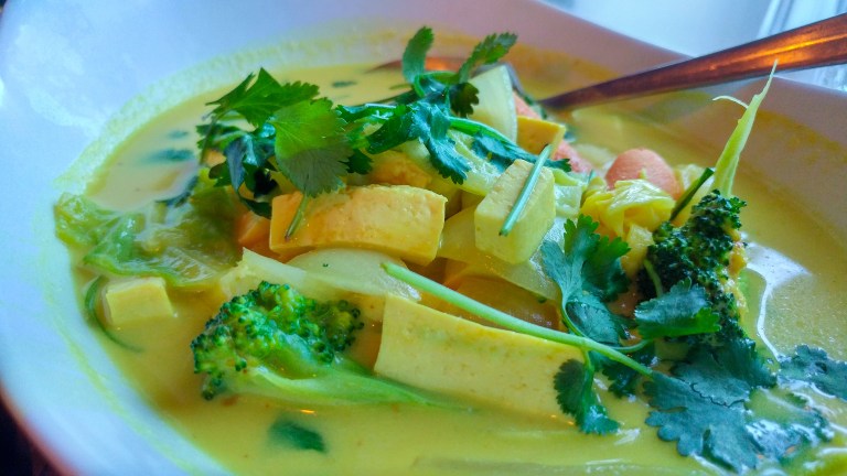
After our hike, we had just enough time to pop into nearby Dunsmuir to have dinner at Sengthong’s Blue Room, which closed at 8PM. We were the last customers in the restaurant! The Thai curry and pad Thai (both vegetarian) were nicely flavored, not very spicy, and not too heavy.
The antique pictures on the wall, the saloon vibe, and the Ella Fitzgerald record playing on the record player made for a very cool old-time feel and the perfect end to our first evening. We stayed in Mount Shasta at the Best Western Treehouse, a convenient and pretty comfortable hotel right off I-5, next to three gas stations, and across the street from a grocery store and a few restaurants in Mount Shasta.
Sunday – Volcanic Legacy
On Sunday, we decided to explore two branches of the Volcanic Legacy Scenic Byway. After a quick early espresso at Seven Suns Coffee, we headed north on I-5 past the town of Weed and turned onto U.S. highway 97 north. The views of Mount Shasta bursting through the clouds early in the morning were spectacular.
Our first destination was Yellow Butte, one of the many satellites of Mount Shasta that lies on the Northern side of the mountain in the desert valley in between the Klamath and Cascade Mountain Ranges.
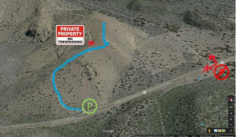
We tried to navigate to the Butte on Google Maps, and it started to take us down a rugged road up the side of a hill off the highway! We quickly realized that we should not have followed the “Yellow Butte Road” (go figure) but should instead have parked off of the highway (here) and then walked through the green gate up the Butte.
After hiking around the first hill, we came to a saddle which provided an excellent view of the mountain.

The main trail to the summit of Yellow Butte is now blocked by a “Private Property” sign, but we took the social trail (which is still open) up to the nearby rocky crest, from which we had a panoramic view of Haystack Butte, the colorful quarry nearby, and the Shasta Valley with mountains in the distance.
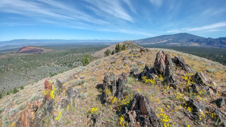
With the main path closed, the walk was short (about a mile total), but it was very pleasant and carpeted with wildflowers and interesting rock formations. Here is a 3D map of the trail we followed, as well as the parking area and the fenced off main trail.
Next, we visited the beautiful Living Memorial Sculpture Garden, which features the moving statues of artist Dennis Smith against the natural backdrop of trees and mountains. The sculptures tell the stories of all of those touched by war, including wounded warriors, POWs, nurses, widows, peace activists, and more.


The garden also has a wall honoring veterans. The website has more information about how to become a member of the garden or how to add a name to the wall.
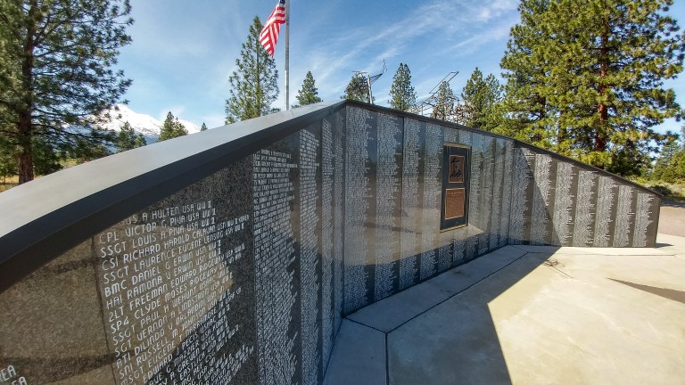
The peace of this place was unique among the memorials we’ve visited, and we would definitely recommend making the trip here if you are staying in the Mount Shasta area.
We were done our morning excursions by around 11AM, and we headed back to Dunsmuir for brunch, but in retrospect, we could have saved a lot of time by getting a quick breakfast at one of the chain restaurants in Weed.
After breakfast, we drove down another leg of the Volcanic Legacy Scenic Byway, this time traveling south/east from Mount Shasta on state route 89. Along this road, we got to see four spectacular waterfalls.
The first set of falls we came across were the Lower, Middle, and Upper Falls of the McCloud River – none of these have a day use fee (contrary to old signs that indicate otherwise), any many people had brought their dogs on the trail. You could park at either the upper or lower falls and walk to the others (4 miles roundtrip), but we decided to split this excursion into two parts to save some time.
First, we made a quick stop at the lower falls to observe them from the overlook. We accidentally parked near Fowler’s Camp, but day-use parking is actually available further down the same road. The lower falls tumble over some basalt rocks about 15 feet, but the flow of water makes them a very impressive sight!
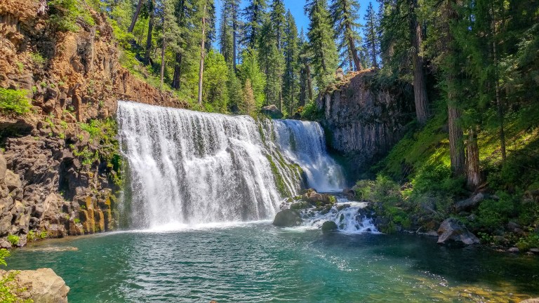
We hopped back in the car, drove back towards the highway, and then turned towards the Middle Falls (on Middle Falls Road, which you reach before you get to the highway). We parked at the Middle Falls Parking lot. The overlook nearest the parking lot provides a great view of both arms of the McCloud River surrounding the falls.
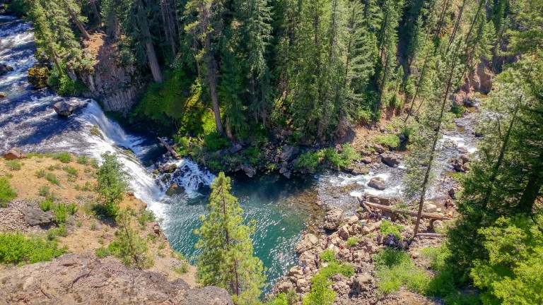
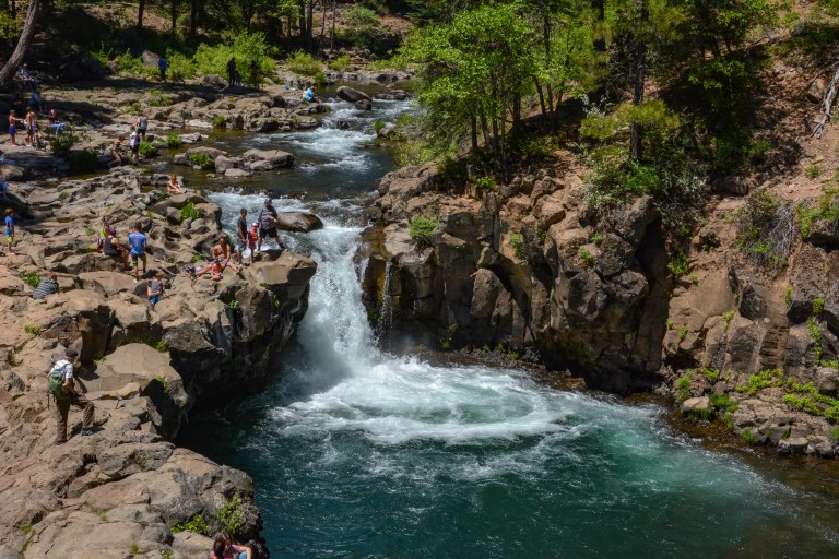
We walked down to our right to get a head-on view of Middle Falls. Most people consider this the highlight of the McCloud River because of the width of the falls here.
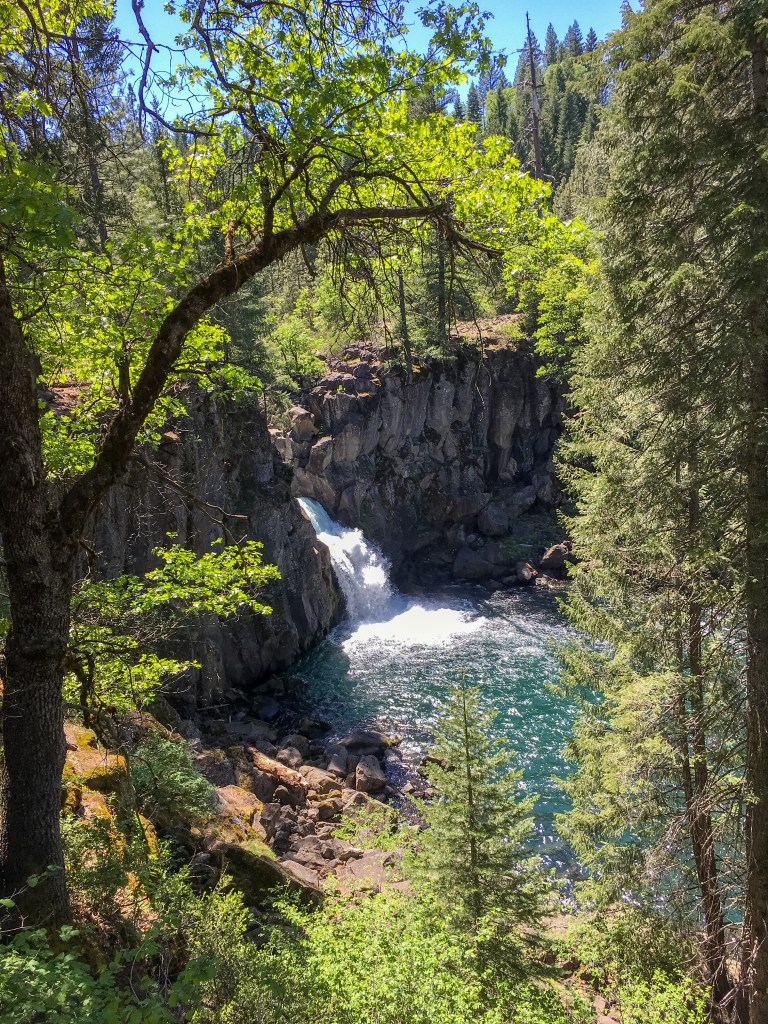
After taking in the falls for a few minutes, we retraced our steps back up towards the parking lot and followed the river to find the Upper Falls. The upper falls are super impressive because they have pierced through a wall of basalt columns at this point. Both the volume of water here (fed by water deep in the volcano) and the basalt columns are evidence of the “Volcanic Legacy” that gives this highway its name. The Upper Falls are beautifully framed by trees from the overlook.
We walked a bit further on the trail to see more of the river, and then headed back to the parking lot to continue about 40 minutes further down highway 89 to McArthur-Burney Memorial State Park, the second oldest park in the California State Park System. Google seems to undershoot the park’s location, but just keep driving and you’ll see a sign for the park entrance. We were a bit worried because a “Park Full” sign was displayed outside the entrance, but we drove up to the entry booth anyways, and after paying the $8 entry fee, the ranger directed us to an overflow parking area (on the Headwaters Trail). If the park were actually totally full, the park website notes that it would illegal to park along the highway and advises visitors to return at a later time.
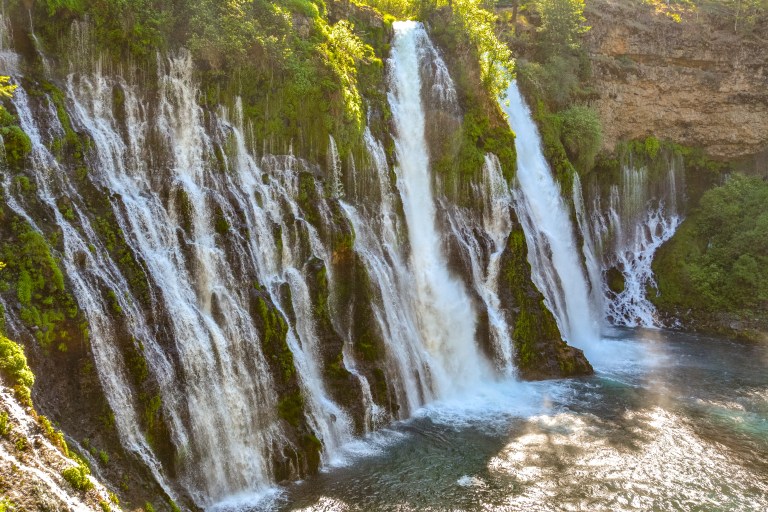
The highlight of the park is the spectacular Burney Falls, which can be accessed along a paved path that starts near the visitor center.
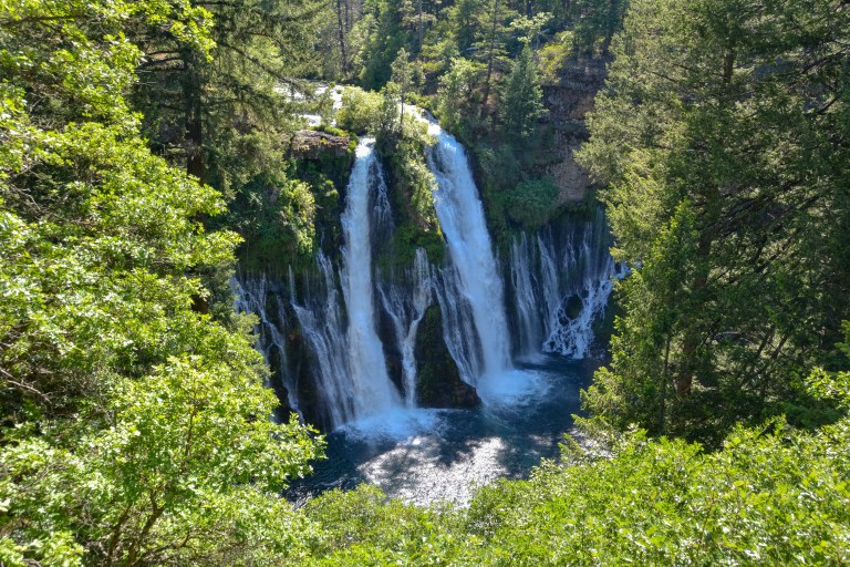
The falls are a mixture of a cascade of water in Burney Creek and spring water coming through the rocks, which give the falls their intricate branching structure. If you can scramble over the rocks (and past the hordes of visitors), you can get an amazing view of the falls up close.
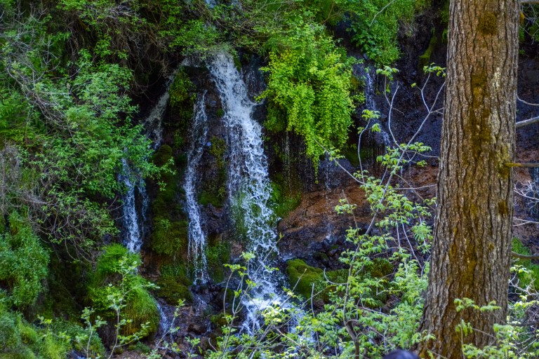
Further down the trail, you can see additional small branches of water trickling down the sides of the canyon.
You can do a full loop around the falls, but we just retraced our steps back to the visitor center. Before we left the park, we got a $2 soft-serve ice cream cone in the General Store to beat the afternoon heat (the chocolate flavor was nice and strong)!
For our final destination of the day, we drove all the way back towards Mount Shasta town and then headed west into the Trinity Mountains to visit Castle Lake and Heart Lake (1 hour and 15 minutes of driving). These lakes are formed by glacial melt, unlike unlike the nearby Siskiou Lake and Shasta Lake, which are formed because of the damming of the Sacramento River. The area has an interesting Canadian connection: the first non-natives to explore this area were Hudson’s Bay Company “coureurs des bois” looking for beaver and other pelts for the fur trade.
Because it was almost 6PM by the time we reached the Castle Lake Parking Lot (past the campground on Castle Lake Road), we decided to first make the short trek to Heart Lake, about 2 miles round-trip, before we lost too much daylight. The trail starts on the eastern side of Castle Lake, i.e. you walk clockwise around the lake from the parking area. The Forestry service doesn’t maintain this trail or the signage to Heart Lake, but we didn’t see any “private land/no trespassing” signs as indicated on the US Forestry Service webpage.
The trail around the lake was fairly straightforward as it wound its way through the trees, with beautiful filtered views of Castle Lake on the right.
 We got a little lost once we exited the forest into a more open, rocky area, but in general, we found that wherever there was a split in the trail, we stayed on the correct path if we took the right-hand fork towards higher ground on the horizon.
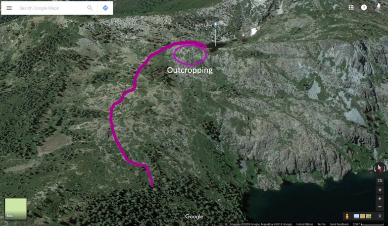
A helpful hiker pointed us towards a rocky outcropping above us, which was a good landmark to follow along the trail (you follow a clockwise arc to walk towards this point).
We also found that the AllTrails map of the path to Heart Lake was very accurate and cell phone reception was pretty strong in this area, so using cell phone GPS to locate ourselves on the AllTrails app proved to be the most useful strategy for finding our way.
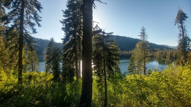
Finally, we made it to Heart Lake! We walked around the lake counterclockwise, first stopping to get a jaw-dropping view of Castle Lake below us, and Black Butte and Mount Shasta in the distance.
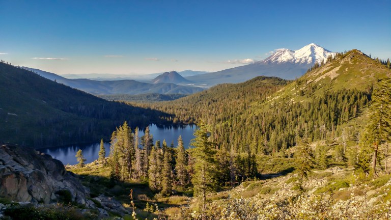
Continuing around the lake and walking over some rocks across a small stream, we got to a nice clear view of Mount Shasta over the lake. We saw lots of people camping around the lake, and that was no surprise considering that it looked like an ad for camping equipment.

You can take trail on the far side of Heart Lake to the Castle Lake Overlook, but because of the late hour, we decided to turn around at Heart Lake and retrace our steps to the car (luckily, the path was very visible on the way down). We arrived back at the trail head just in time to catch a lovely yellow-orange glow of the sunset reflecting off the head wall of Castle Lake.
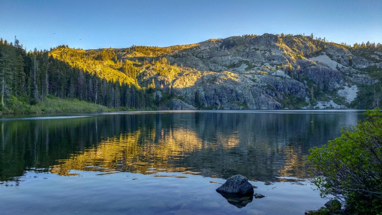
- Sunset in Castle Lake
This was our final destination of our very full day, so we headed back to town, had dinner, and called it a night.
Monday – The Journey Home
After some delicious early morning espresso at Yak’s Koffee and a walk through Mount Shasta’s downtown (not much was open early), we hit the road for home. If you’re looking for a nice morning outing, we’d recommend stopping in Dunsmuir to visit Hedge Creek Falls (about 10 minutes south of Mount Shasta in Dunsmuir). We actually did this walk earlier on our trip, but geographically it makes a bit more sense to do it on your way back to the Bay Area. There is a small parking lot just off the highway on Mott Road/Dunsmuir Avenue, and the trail head is across the street (there is no cost to visit the falls).
A unique aspect of this trail compared to the other waterfalls we visited on Sunday was that we were actually able to walk behind the falls. Seeing the cascading water framed by ferns growing on the basalt from behind was a marvelous sight!

We made another stop in Redding (about another hour on the highway) on the way home. We had a wonderful breakfast at Trendy’s, a family-run restaurant just outside of the main downtown area. It was awesome that we were able to get small portions of the Eggs, Pancakes, and French Toast so we could try a bit of everything! The breakfast potatoes were delightfully crispy and garlicky, the pancake was tasty and huge, the French Toast (with a Panko coating) was sweet and a bit crunchy, and the biscuit was enormous and uniquely fluffy. The homemade preserves (apricot and jalapeno) were also out of this world! The service was super warm and friendly, like you were dining with old friends. This was one of the best meals we had on our trip!

After breakfast, we took a quick look in the nearby Enjoy (The Store), which features unique albeit somewhat expensive items from local artisans. If you are looking for something special to bring home or as a gift from your trip, this store is definitely worth considering.
Our last stop was Redding’s famous Sundial Bridge, one of only two in the world with similar construction.

There was a free parking lot next to the pathway to the bridge at Turtle Bay, and we spent about 15 minutes walking across the bridge and back to admire its unique construction, the boaters on the Sacramento River, and Lassen Peak in the distance.
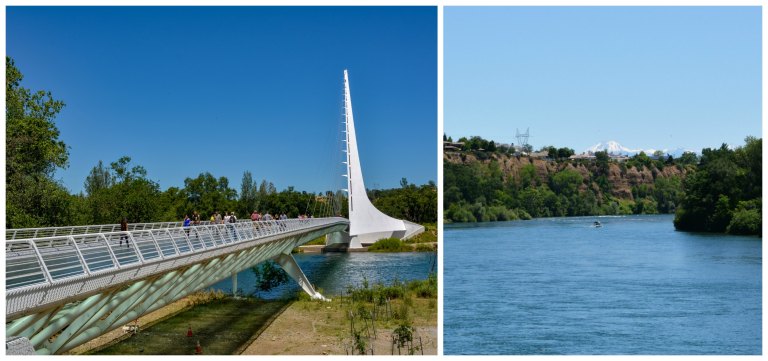
Be sure to look for the time markings on the mosaic arc on the far side of the bridge; we almost missed them! The bridge was telling pretty accurate time because we’re only about a month away from the summer solstice.

If you have more time in the area, you could also explore the adjoining Turtle Bay Park (which has an admission fee) or the arboretum (which is accessible for free with donations encouraged) on either side of the River. We were hoping to beat the rush of traffic returning to the Bay Area after the long weekend, so we called it a day here, hopped back in the car, and made it home in about 4 hours, giving us plenty of time to decompress after our trip and contemplate all of the amazing sights we had seen!
What are some of your favorite activities in the Shasta Area? We’d love to hear some of your tips and suggestions in the comments below!
