

This post is the fifth in a seven part series about our trip through six national parks and other landmarks in Arizona and Utah over Labor Day Week in September.
Sometimes the journey is just as important as the destination, and today was definitely one of those days. After visiting Bryce Canyon, we were looking for the optimal way to drive to Moab, UT, the gateway city for Arches and Canyonlands National Parks. The most direct route suggested by Google takes 4.5 hours but completely skips over three gems on federal lands in this part of Utah: the Grand Staircase-Escalante National Monument, Capitol Reef National Park, and the Mill Canyon Dinosaur Track site. This was one of the longest days of our trip, with over 5.5 hours of driving and 7.5 miles of hiking, but it also revealed some of the least crowded and most unique scenery we saw.
This is our suggested itinerary for the day:
- Drive along scenic highway 12 to the Calf Creek Trailhead in the Grand Staircase-Escalante National Monument. Bring a swimsuit and towel and take the mostly flat trail to swim beneath Lower Calf Creek Falls. (1.5 hour drive + 2.5 hour hike and swim)
- Grab lunch at Magnolia’s, a cute school bus/food truck in Boulder, UT (20 minute drive)
- After lunch, continue to Capitol Reef National Park. First, check out the Hickman Natural Bridge Trail, which lies along highway 24, and then grab some pie at the Gifford Homestead. (1 hour drive + 1 hour hike)
- If you’re in the mood, you can check out a small section of the Capitol Reef Scenic Drive, and then continue to Mill Canyon, where you can see real dinosaur tracks preserved in a 112 million year-old bed of algae (2.5-3 hour drive)
- Continue on to Moab, where you can have dinner and settle in for the night (20 minute drive)
Logistics
- Moab was the logical destination for this part of the trip: it is the gateway city for Arches and Canyonlands National Parks, and also has many dining and lodging options. We stayed at the brand-spanking-new Homewood Suites in the center of town, which was an easy walk from good coffee and good restaurants.
- Make sure to bring plenty of water and sunscreen on your hikes, since most of these were pretty exposed on this day.
Itinerary
After an early breakfast at our hotel in Bryce Canyon City, we packed up and hit the road around 8AM and followed scenic highway 12 to Calf Creek Campground. If you have an Interagency Pass (i.e. the America the Beautiful Pass), you can park in the day use spots for free.
Calf Creek is a beautiful, green oasis that sits in the middle of a rugged rock section of the Grand Staircase-Escalante National Monument. The 2.9 mile trail to the falls is mostly flat and follows the creek, passing by beautiful plants and rock formations.
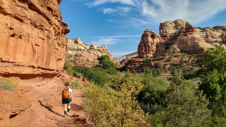
At the trail head, you can pick up a free nature guide that details some of the things you’ll see along the trail (marked by numbered posts). One of the most interesting sights is a set of large rock drawings made by the Fremont Indian people, dating to 1200 CE. The drawings are on the large rocks across the highway from the trail, so a good zoom lens or binoculars will help you see them up close.

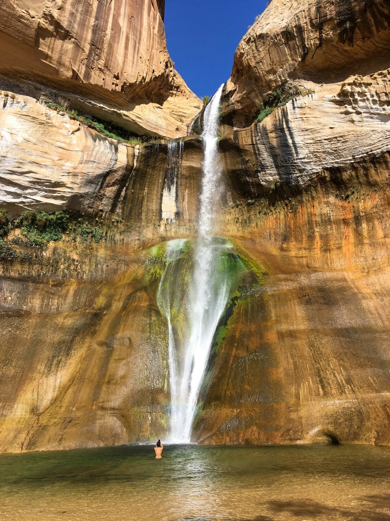
At the 2.9 mile mark, we reached Lower Calf Creek Falls. The combination of the crystal-clear water, the yellow and green tones of the algae-covered rock, and the blue sky above are unlike anything we’ve ever seen. Swimming in the water and coming up close to the 130-foot high fall really gives you a sense of its incredible scale. The water is cold, but well worth getting wet if you’re so inclined!
After a quick dip, we backtracked back to the car (for 5.8 miles of total hiking) and continued along highway 12 to Boulder, UT. We stopped for lunch at Magnolia’s, a food stand inside of a school bus that sits outside of the Anasazi State Park Museum. The tacos we had were very fresh and tasty, and the menu included several vegetarian options.

After lunch, we continued to Capitol Reef National Park, perhaps the least visited of the mighty five parks in Utah. Its main geological feature is the waterpocket fold, a long uplift in the Earth’s crust. You can only really see the fold from viewpoints at the southern end of the park, which are pretty hard to access in such limited time, but the rugged rock formations you see throughout the park are in part defined by this feature. Note that you don’t need an interagency pass to explore most parts of the park except if you decide to check out the scenic drive.
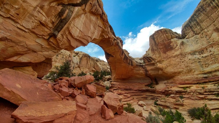
We chose to start on the Hickman Natural Bridge Trail, a 1.8 mile hike that starts right off the highway. Parking can be hard to come by here, but there is a decent amount of turnover if you can’t find a spot right away. The trail leading to the bridge was reasonably steep and took us by a number of beautiful rock formations that were pretty characteristic of this part of the park.


The arch itself was also beautiful, accessible by a loop at the end of the trail. We found that we got the best pictures by being on the near side of the arch and looking up towards the sky.
After getting back to the car after our hike, it was time for a snack! Capitol Reef has an interesting history as a flourishing Mormon agricultural town. You can see evidence of this in Fruita, which is the town surrounding the main entrance to the park, where you’ll find old schoolhouses, homesteads, barns, and a number of active orchards where you can pick fruit. A piece of pie and ice cream from the historic Gifford Homestead was a great refreshment after our hike!


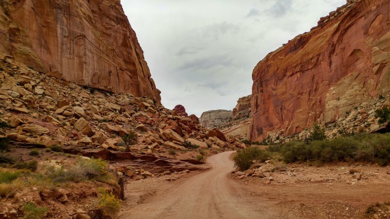
Before leaving Capitol Reef, we decided to explore part of the scenic drive through the park. Indeed, the rugged rock formations and rock slides were very impressive. If you are in a regular passenger vehicle, though, we’d recommend being careful if you take either of the spur roads (the Grand Wash or Capitol Gorge Road) off of the main paved part of the scenic drive. We tried going down the Grand Wash, but the road was very rough on our car. From Google Street view, it appears that Capitol Gorge (which is defined by the narrow, tall canyon through which you have to drive) is quite a bit smoother, but the road conditions can vary dramatically depending on recent rains and other factors.
After finishing up at Capitol Reef, we continued on to Moab. We had read that around Moab, there are several good dinosaur/fossil beds, and it seemed like this would make a nice final stop on our drive. We chose to visit Mill Canyon, a Bureau of Land Management site you’ll cross about 20 minutes before you get to Moab. The canyon is not very well marked from the highway; to reach it, you take a right (west) onto Mill Canyon Road off of highway 191, cross a set of train tracks, and drive through a private roadway and onto the Bureau of Land Management site (do not stop or hike along the private roadway). Follow the signs for the dinosaur track site. Note that there is also a dinosaur trail here, which features bones still encased in rock, but we didn’t have time to visit on this trip because we got there so close to sunset.
When we arrived, we had the track site all to ourselves! From a short wooden boardwalk, we were able to see how dinosaurs and giant crocodiles left tracks in a 112 million year old algae bed, and how these beds became hardened into rock over time, leaving evidence of the creatures that roamed here so long ago. Some of the footprints were huge – 12 to 20 inches or more!


After a very long, full, and fun day, we had finally arrived in Moab! In our next post, we have more details about places to eat in Moab, as well as an account of our electrifying day in Arches National Park, Canyonlands National Park, and Dead Horse Point State Park!

One thought on “Calf Creek, Capitol Reef, and Mill Canyon”