

This post is one in a series of posts from our recent trip to the Canadian Rockies and Glacier National Park in Montana. More to come soon!
There are very few things that could get us out of bed at 4AM, but being at Moraine Lake for sunrise (more practically, being able to park at Moraine Lake) is definitely one of them. The weather for our first full day in the Canadian Rockies looked clear and sunny for most of the morning, so we decided to get an early start to explore several of the iconic mountain lakes that make Banff National Park so famous: Moraine Lake, Lake Louise, and Peyto Lake.
Itinerary
- Leave Banff/Canmore very early and arrive at the Moraine Lake Parking Lot by 5:30AM. [~1hr 15 min of driving from Canmore]
- Take a quick stroll up to the top of the Rockpile Trail or by the boathouse to catch a glorious sunrise over the mountain peaks. [30-45 minutes including time for pictures]
- Drive back to Lake Louise and try to secure a parking spot by around 7AM. [20 min of driving]
- Hike the Plain of Six Glaciers/Lake Agnes grand loop, enjoying a picnic or lunch at one of the teahouses on the trail. [9.6 miles, 2648ft elevation gain]. If you have limited time or want a shorter hike, consider the 1.5 mile trip to Fairview Lookout for a different perspective on the lake.
- In the afternoon, drive along the Icefields Parkway to Bow Summit, which offers grand views of Peyto Lake and plenty of paths to explore. [45 minutes of driving and 1 hour to explore].
- On your way back to Banff for dinner, consider stopping at Bow Lake and the Crowfoot Glacier Viewpoint. [1hr 30 min driving]
Logistics
- We saw a grizzly bear out here! Make sure you carry bear spray and know how to use it. Also, if you see any large wildlife while on the trail or on the road, give it plenty of space and call Banff dispatch at 403-762-1470.
- You need a valid park pass to be displayed in your vehicle to stop anywhere inside Banff National Park. The pass also lets you bypass the entrance stations on the TransCanada Highway from Canmore (take the rightmost lanes), and every minute counts when you are trying to get a parking spot at Moraine Lake! The pass can be purchased in advance from the entrance station, from a Parks Canada Information Centre (like the one in Banff), or online before your trip. Be sure to leave plenty of time for shipping if you plan to order it online.
- To be sure you can secure a parking spot at the popular lakes, you need to arrive at Moraine Lake before 5:30AM and at Lake Louise before 7:30AM. The day we were there, Parks Canada closed the access road to Moraine Lake by 6AM. We heard mixed stories of what happens later in the day: some people were able to catch a lucky break and sneak in behind a tour bus later in the day and some were able to take a shuttle. Others said they had to wait two hours to catch a shuttle, and some circled the lots at Lake Louise and ultimately gave up.
- On the Icefields Parkway, the parking lots did not seem to fill up as quickly; however, the parking lot at Bow Summit will be closing in on August 19, 2019 for much needed repair work and upgrades, so the Peyto Lake Viewpoint will be inaccessible for part of this year.
- The weather in the Rockies can be variable, and on a long hike, you may start out in the sun but get poured on later. Bring different lightweight layers, rain protection, and good shoes! Your best bet for getting a decent forecast is to use the Environment Canada hourly weather the day before and the day of your excursion. You can also use the area webcams (particularly the webcams at the Banff Gondola, Lake Louise, and the Icefield Center) to get an idea of the cloud cover and rain while you are on the road.
Details
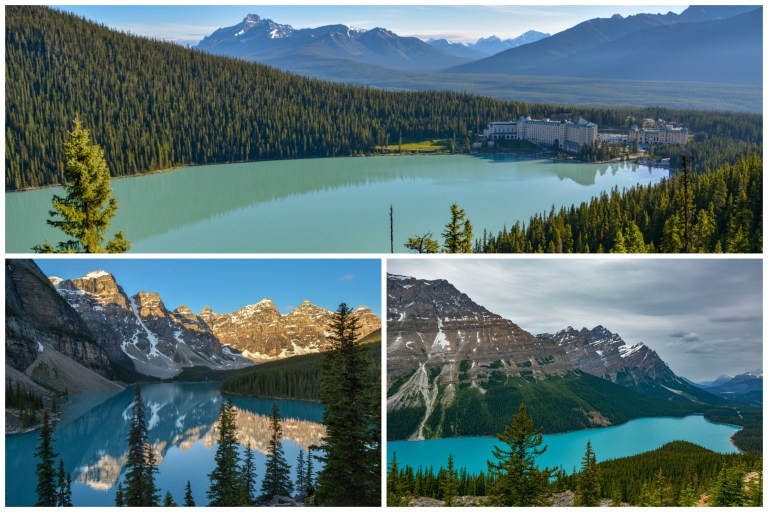
Moraine Lake
The staff at our hotel near Canmore advised us to get up at 4:00M if we wanted to see Moraine Lake, so we did just that. We were out the door by 4:30AM and arrived at the parking lot around 5:40AM. The lot was already full (!!!): luckily, an eager couple was already done exploring the area, and we got their spot just as they pulled out.

From the parking lot, we first took the Rockpile Trail, which is an easy 0.9 mile out-and-back trail to a pair of viewing platforms of Moraine Lake. People were already standing shoulder-to-shoulder at the viewpoint to watch sunrise. Many people were going over the walls and off trail to get “the perfect picture,” but this erodes the landscape, so we stuck to the trail itself and were able to get phenomenal views. We stood here for about 20 minutes as the sun rose and watched the peaks slowly light up, creating a golden contrast to blue waters in the lake.

On the way back down the Rockpile Trail, we noticed the sun creating beautiful colors against the other peaks in the area and really appreciated the beauty of this short trail in its own right.
Once we were back at the parking lot, we took the trail along the lake shore to get a view of the lake from the boathouse. The boathouse is only open from 9AM-5PM, so if you’d like to canoe, consider coming back later in the day by shuttle or doing a longer hike at Moraine Lake first (such as Larch Valley). This view from the shore was also very grand, and there were hardly any people here in comparison with the Rockpile Trail.

Lake Louise and the Plain of Six Glaciers Hike
We left Moraine Lake around 6:30AM and drove over to Lake Louise. We were able to park here, but the lots were filling up very quickly – they were totally full by 7:45AM.
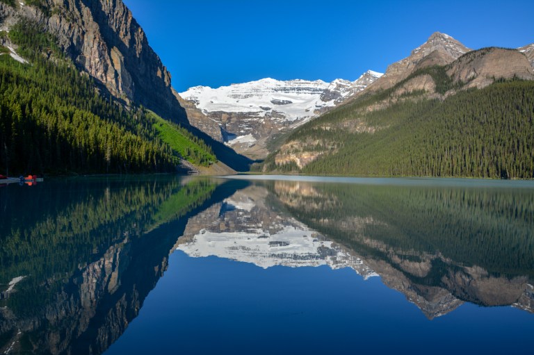
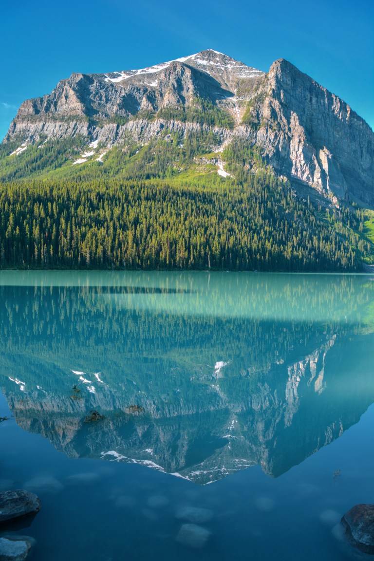
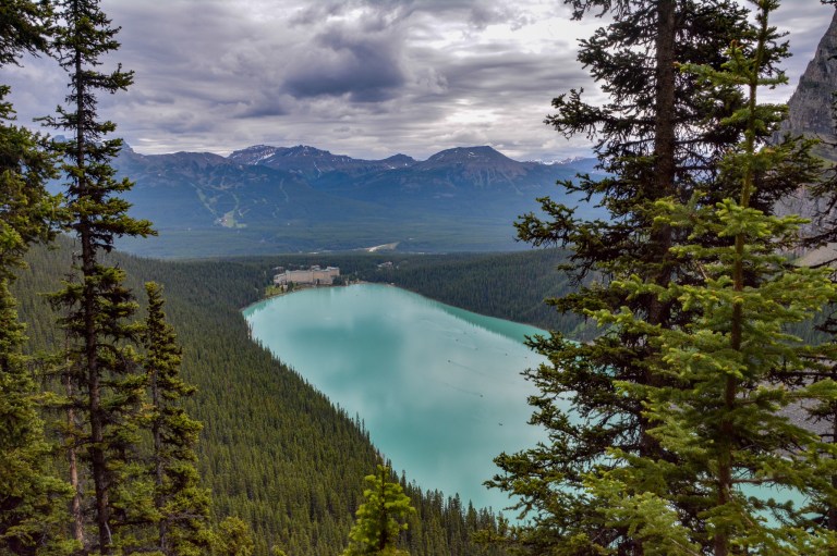
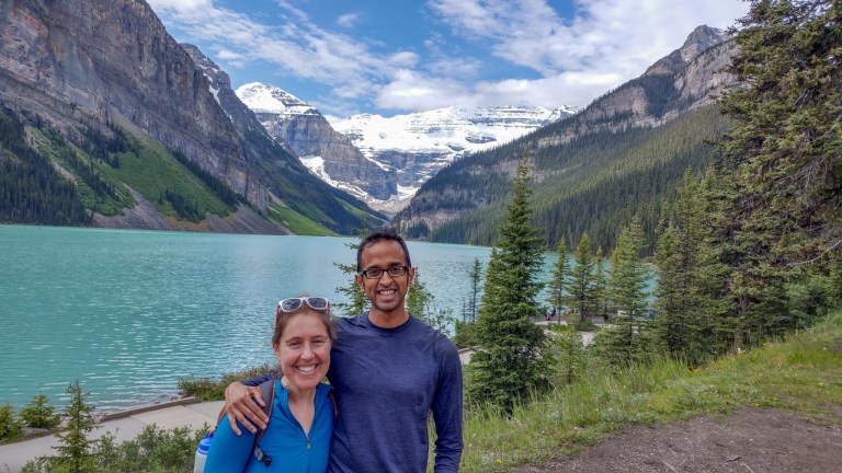
We started by looking at the still waters of Lake Louise from the shoreline near the Fairmont Hotel. The reflection of the Victoria Glacier in the water was breathtaking! The light really makes a difference in the appearance of Lake Louise, so we felt very fortunate to arrive so early to experience it as it changed color. For example, here is a view of the lake at 7AM and again at 8AM. Earlier, the lake takes on the deep blue color of the sky, whereas later, the rock flour scatters more strongly and gives the lake its typical turquoise color.

Our original plan was to hike to the Mount Fairview summit (6 miles roundtrip). We took the shoreline clockwise towards the eastern side of the lake and followed the signs to “Saddleback.” However, after the first half-mile, we realized that we were going to be in the forest for quite a while and not enjoying the beautiful clear weather we had on this day. We decided to cut the hike short by stopping at the Fairview Lookout (1.5 miles roundtrip, 541 ft elevation change), from which we had an awesome view of the Fairmont Hotel framed against jagged mountain peaks in the background and the turquoise lake below. We would strongly recommend this trail if you have limited time in the area because the view from Fairview Lookout is similar to the one from the Beehive or the Lake Agnes Highline Connector on the opposite side of the lake, but with only a fraction of the time and effort needed.

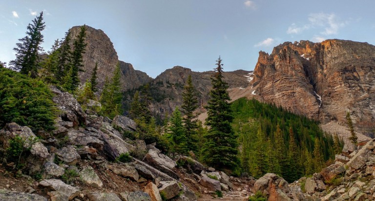
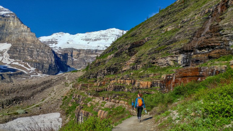
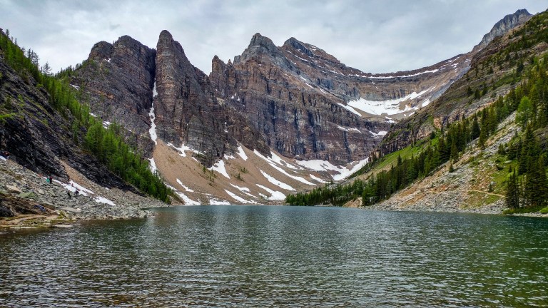
We descended back to the Lakeshore, used the restrooms, and then set off on one of the most classic hikes in the Canadian Rockies, the Plain of Six Glaciers Trail. To do the full grand loop to Plain of Six Glaciers and Lake Agnes (9.65 miles, 2648ft of elevation change), we’d strongly recommend starting off on the Plain of Six Glaciers Trail, which is mostly exposed, and then returning via Lake Agnes, which is more in the woods. That way, you can benefit from the sunshine in the early morning and the shade later. Besides the tremendous scenery, there are also two historic teahouses on this route that serve food and have nearby restrooms. Since we didn’t have much time, we packed a lunch, but we also noticed that by the time we arrived at the Plain of Six Glaciers teahouse, the lines were not too long to buy food there.
We started off by walking counter-clockwise all the way around the western side of Lake Louise. From here, there were tremendous views of Mount Fairview (where we had just come from) reflected in the lake. We continued following the lake shore past the turnoff for Lake Agnes and eventually joined the Plain of Six Glaciers Trail.
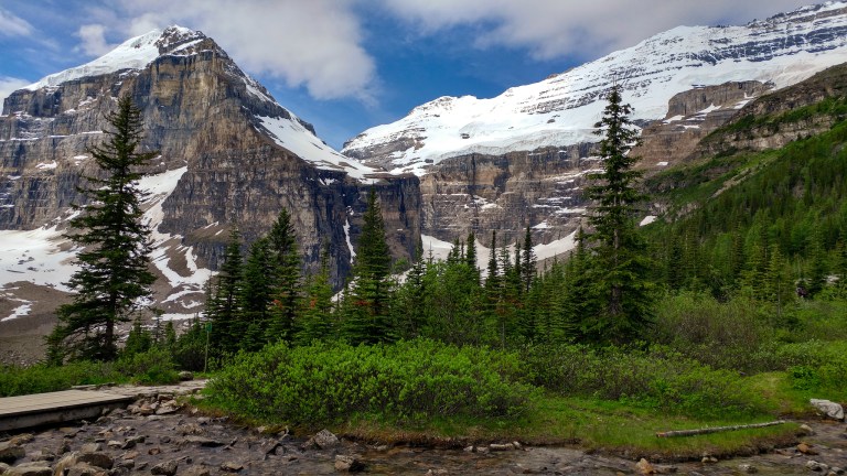
On the backside of the lake, we followed the Plain of Six Glaciers Trail through a partially forested area that offered tremendous views of Mount Lefroy and the glaciers that feed Lake Louise.

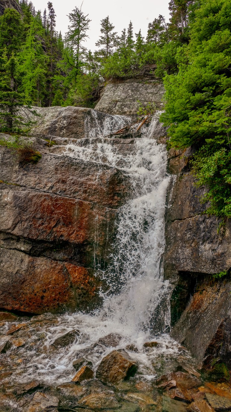
The runoff from the glacial melt created fast-moving streams and waterfalls throughout this valley, including an incredible weeping wall along the trail.
At the 3.5 mile mark, we hit the Plain of Six Glaciers Teahouse (also the location of an outhouse). We made a quick pit stop here before continuing across the bridge to the Abbott Hut (Plain of Six Glaciers) Viewpoint.
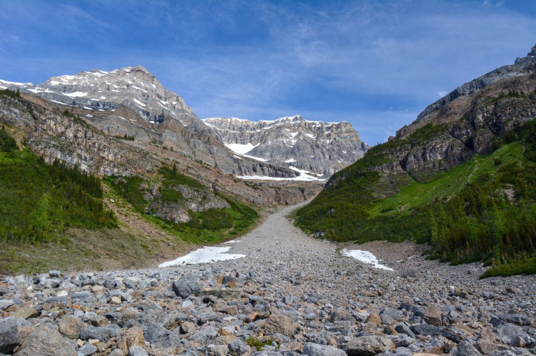
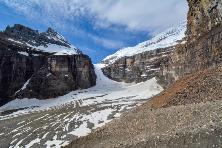
After this point, the trail gets significantly rougher and quite a bit steeper. We didn’t need hiking poles but did need to rest a bit and take it slow both on the way up and down, so this section added on about an hour or so to the journey. The up-close views of the glaciers we got along this section were definitely worth the trek.
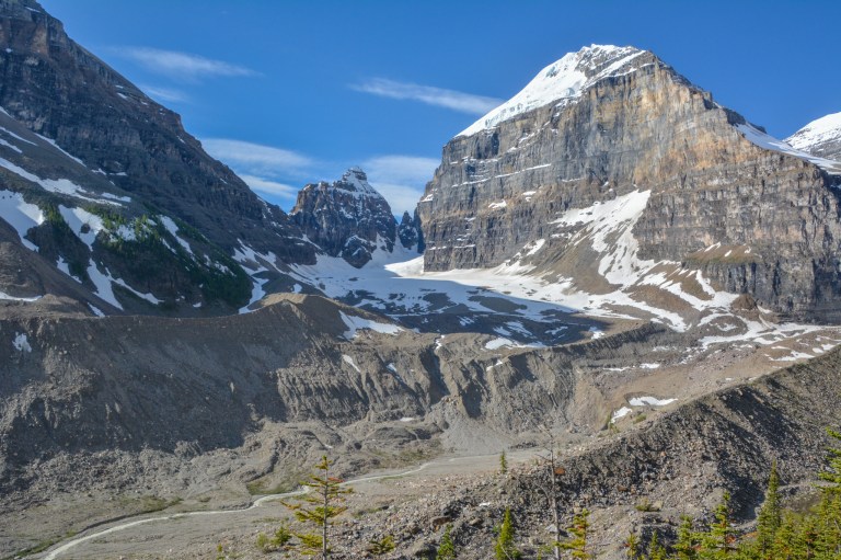
While hiking over the rocky ridges of different moraines, we had neat perspectives on Mount Lefory, the jagged Mitre, and the rivulets of glacial runoff in the valley.
The last stretch of the hike aimed us at the pass in between the Victoria Glacier and Mount Lefroy.

We had awesome panoramas of the snow in the area.

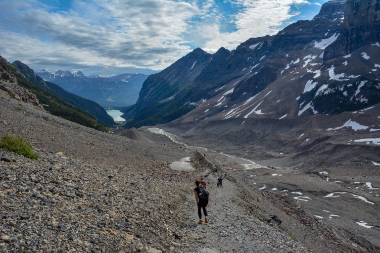
A good stopping point is a pull-out on the trail that is flanked by two large boulders. We continued on further to get a complete view around the corner of Mount Lefroy.
After stopping on the rocks for a quick breather, we turned around and backtracked down the trail. The trail at this point was very steep and loose, so we took our time coming back down!
 We had a picnic lunch on one of the benches near the teahouse. After lunch, we continued back the way we came. The view of Lake Louise down the valley from here was awesome.

Around the 5.7 mile mark, we reached a junction on the left for a connector to the Highline Trail, which links the Plain of Six Glaciers with Lake Agnes. We took this trail which runs parallel to and above the Plain of Six Glaciers Trail. It was a little more forested but covered in wildflowers, giving more of a birds eye view of the valley we just walked through.
At the 6.7 mile mark, you can take a trail on the left to the top of the Big Beehive for another viewpoint of the lake. We instead continued straight, and there were peek-a-boo views of the lake right from the Highline Trail. It was fun to see all the canoes zipping around on the surface of the water!
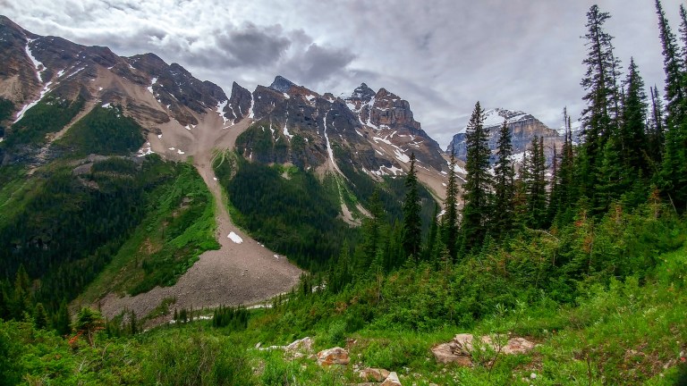
At the 7.4 mile mark, we took the left fork in the trail up to Lake Agnes. The trail to Lake Agnes from the connector trail is pretty steep in parts, but the views of the jagged peaks around the lake are well worth it!
The teahouse at Lake Agnes was totally mobbed in the early afternoon, so we continued around the backside of the teahouse and down to Mirror Lake. We passed a beautiful waterfall along the way.
 In Mirror Lake, you can see a full reflection of the Beehive in the water if you stand on a tall rock near the shoreline.

From Mirror Lake, it was a pretty easy 1.6 miles back to the shore of Lake Louise. All in all, it took us about 5.5 hours to complete this awesome and scenic hike!
The Icefields Parkway and Peyto Lake
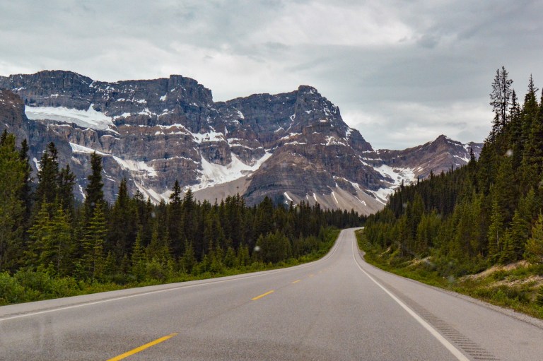
A big storm system was due in the region starting the next day, so we decided to tack another excursion onto our day: exploring the Columbia Icefields Parkway. The parkway is the road that connects Banff and Jasper, but we only took it as far as its highest point, Bow Summit, about 40 minutes from Lake Louise. The scenery along the Icefields Parkway is some of the most dramatic roadside scenery in the Rockies.
The road’s natural beauty doesn’t stop with the mountains – the wildlife can be spectacular, too! We got extra lucky and spotted a grizzly bear near the side of the road. Several cars had already stopped to take a look.

This mother bear was out with her cub, and so after a quick look we continued on to avoid disturbing her. Later, we called in the bear sighting to Banff dispatch, who uses this information to help track the movement of the bears within the park.
About 40 km down the Icefields Parkway, we turned in to the Bow Summit Parking Lot. The lot was pretty full at this time in the mid-afternoon, but there were still enough spaces for us to pull in without issue.
The hike up to Peyto Lake Viewpoint is about 1 km each way along a steep but paved path. It is an amazing vista over another stellar mountain lake with the northern peaks of Banff National Park stretching off into the distance. Nearly every person who walked up to the viewpoint – including us – uttered an audible “wow” when they saw the incredible blue color of the lake.

From the viewpoint, you can continue exploring the dirt and gravel paths higher, which take you to other viewpoints of the lake, to Bow Summit itself, and can even backtrack you down to Bow Lake further south on the Icefields Parkway. We walked partway to the summit to take in a grand view of Peyto Lake from another perspective and then headed back to the car.

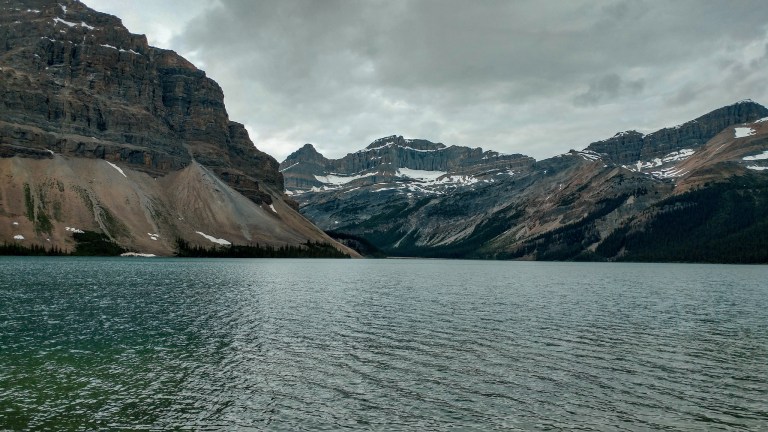
At this point, we decided to call it a day and backtrack towards Banff. We got two bonus views of lakes and glaciers heading back towards Lake Louise: Bow Lake (which lies just south of Bow Summit) and Crowfoot Glacier (so named because of the three “toes” of the glacier) are both easily accessible from pullouts heading south on the Icefields Parkway.

We were back in Banff about an hour and a half later, hungry and tired but still amazed by all the beautiful scenery we saw on the first day of a very exciting trip!
Stay tuned for the next part of our adventure at Lake O’Hara, one of the most exclusive and beautiful destinations in the Canadian Rockies.

Such beautiful photos! Looks stunning 🙂
LikeLike
Thank you!
LikeLiked by 1 person